
Explore our enterprise software platforms built to convert data into measurable, operational intelligence.
Explore DJI Terra
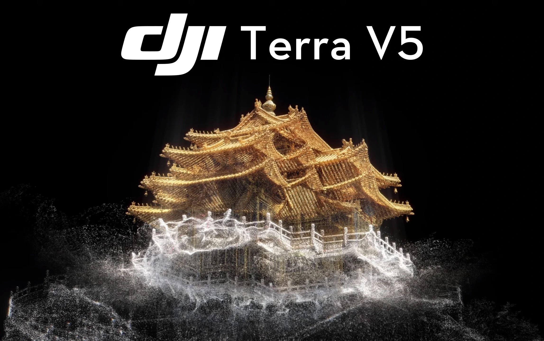
DJI Terra
Advanced Drone Mapping and 3D Reconstruction Software
DJI Terra is a powerful photogrammetry and LiDAR processing platform designed to transform drone captured data into accurate 2D maps, 3D models and point cloud outputs. Built for surveying, inspection and infrastructure applications, it enables professionals to convert aerial imagery into actionable geospatial intelligence.
From corridor mapping and terrain reconstruction to asset modelling and volumetric analysis, DJI Terra provides the processing tools required to turn captured data into measurable results.
Product Overview
DJI Terra is purpose built to process aerial data captured by DJI enterprise platforms. It supports photogrammetry workflows, LiDAR point cloud processing and multi mission reconstruction to deliver precise mapping outputs for demanding operational environments.
Designed for surveyors, engineers and infrastructure operators, DJI Terra streamlines the transition from data capture to deliverable output. It integrates seamlessly with DJI drones and payloads, ensuring reliable and efficient processing from field to office.
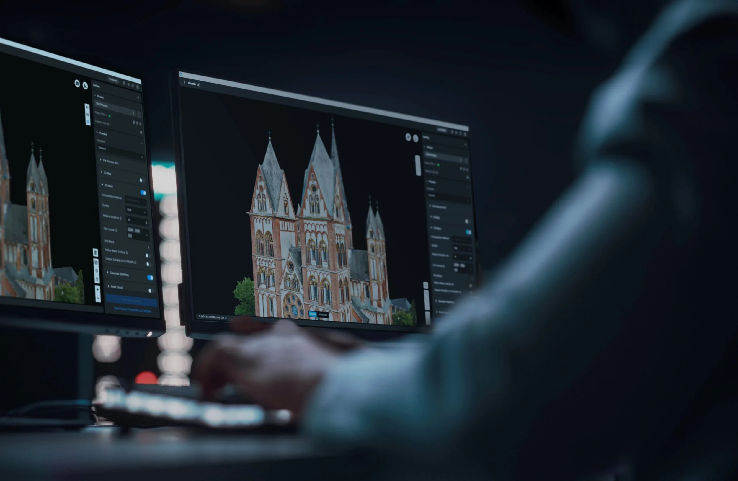
2D and 3D Reconstruction
High Accuracy Mapping and Modelling
DJI Terra converts RGB image datasets into high resolution orthomosaics, digital surface models and detailed 3D reconstructions suitable for surveying, planning and inspection.
Advanced processing algorithms enable accurate model generation from automated flight missions, ensuring consistent results across complex sites.
Generate high resolution orthomosaic maps
Produce digital surface and terrain models
Create textured 3D reconstructions
Integrate ground control points for enhanced accuracy
Export industry standard formats for CAD and GIS platforms
This enables professionals to extract precise measurements and reliable spatial data directly from drone captured imagery.
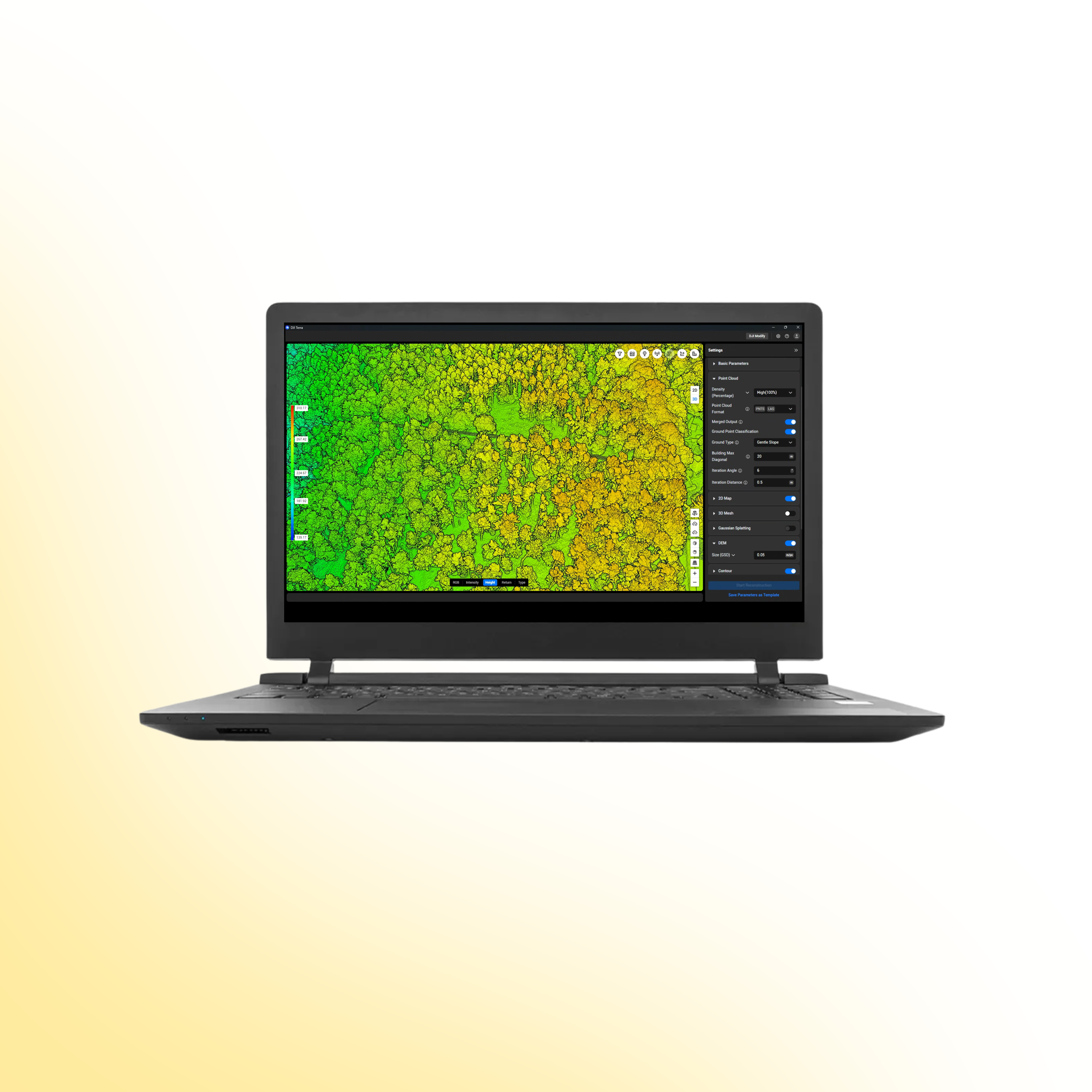
LiDAR Processing and Advanced Analysis
Dense Point Cloud Interpretation and Measurement

DJI Terra supports LiDAR data processing for terrain modelling, infrastructure analysis and environmental assessment. The platform enables classification, reconstruction and refinement of dense point cloud datasets captured by compatible DJI payloads.
Integrated analysis tools allow users to derive measurable outputs from complex environments.
Process and classify LiDAR point cloud datasets
Generate digital elevation and terrain models
Reconstruct detailed 3D terrain surfaces
Conduct distance, area and volumetric measurements
Support corridor mapping for linear infrastructure
Export LAS and other industry compatible formats.
This allows operators to analyse terrain, vegetation and structural assets with high precision and confidence.
Drone Systems
Advanced aerial systems engineered to expand operational capability, accuracy and mission performance.
DJI Matrice 400
The DJI Matrice 400 is an advanced enterprise drone platform engineered for complex industrial operations. With extended endurance, heavy payload capacity and intelligent sensing systems, it supports inspection, infrastructure, utilities and mission-critical deployments at scale.
DJI Dock 3
The DJI Dock 3 is an autonomous drone system designed for continuous remote inspection and public safety operations. Integrating automated deployment with Matrice 4D or 4TD aircraft, it delivers reliable aerial oversight in demanding environments.
DJI Matrice 4E
The DJI Matrice 4E is a compact mapping drone built for high-accuracy surveying and geospatial workflows. Featuring a mechanical shutter wide-angle camera and advanced capture modes, it enables efficient orthophoto and 3D data collection across construction, mining and infrastructure projects.
DJI Matrice 4T
The DJI Matrice 4T is a compact multi-sensor drone designed for inspection, public safety and emergency response operations. Combining high-resolution zoom, thermal imaging and a laser rangefinder, it delivers actionable visual and temperature data for complex missions in challenging environments.
Payloads
Advanced sensor solutions designed to expand capability, accuracy and mission performance.
DJI Zenmuse L3
The Zenmuse L3 is a high precision LiDAR payload designed for detailed 3D mapping and terrain modelling. It captures dense point cloud data with integrated RGB support, making it ideal for surveying, corridor mapping and infrastructure inspection in complex environments.
DJI Zenmuse P1
The Zenmuse P1 is a full frame photogrammetry payload built for efficient large scale mapping. With high resolution imaging and a mechanical shutter, it delivers accurate 2D and 3D data for construction, land surveying and infrastructure projects.
DJI Zenmuse H30T
The Zenmuse H30T combines high resolution zoom optics with thermal imaging for inspection and public safety operations. It enables operators to detect anomalies, monitor assets and gather visual and thermal data from a safe distance.
DJI Zenmuse L2
The Zenmuse L2 integrates LiDAR scanning with an RGB mapping camera to deliver high accuracy terrain capture and asset modelling. It produces reliable point cloud and colourised data for surveying, infrastructure inspection and corridor mapping operations.
Software
Advanced software platforms designed to transform drone data into accurate insight and operational intelligence.
DJI Terra
DJI Terra is a professional drone mapping platform designed for processing aerial imagery and LiDAR datasets. Supporting photogrammetry reconstruction and terrain modelling, it converts captured drone data into accurate maps, 3D models and measurable outputs for surveying, construction and infrastructure analysis.
DJI FlightHub 2
DJI FlightHub 2 is a cloud based drone operations platform designed for remote fleet management and mission coordination. Integrating real time data streaming, flight planning and team collaboration, it provides centralised control and operational visibility for enterprise drone deployments.
FAQs
-
DJI Terra is a professional drone mapping software platform used to convert aerial imagery and LiDAR data into accurate maps, 3D models and measurable datasets for surveying, construction and infrastructure analysis.
-
DJI Terra supports multiple DJI Enterprise platforms including Matrice 350 RTK, Matrice 300 RTK, Matrice 400, Matrice 30 Series and Matrice 4 Series when paired with compatible payloads.
-
Yes. DJI Terra supports LiDAR data captured by compatible DJI payloads and enables users to generate dense point cloud datasets, terrain models and detailed 3D reconstructions.
-
Yes. DJI Terra can process aerial imagery to generate high resolution orthomosaic maps suitable for surveying, inspection and site analysis.
-
Yes. DJI Terra can generate textured 3D models from drone captured imagery, allowing users to visualise and analyse environments in three dimensions.
-
Yes. DJI Terra includes measurement tools that allow users to calculate distances, areas and volumetric measurements directly within processed models and maps.
-
Yes. Ground control points can be integrated into processing workflows to improve positional accuracy for mapping and surveying applications.
-
DJI Terra supports a range of industry standard output formats including LAS point cloud files, orthomosaic imagery and 3D models compatible with CAD, BIM and GIS platforms.
-
Yes. DJI Terra supports corridor mapping workflows designed for linear infrastructure such as power lines, railways and pipelines, enabling accurate modelling across long distances.
-
Yes. DJI Terra supports multi mission reconstruction, allowing datasets captured across multiple flights to be combined into a single reconstruction for large area mapping projects.
-
DJI Terra is widely used across surveying, construction, utilities, mining, infrastructure inspection and environmental monitoring where accurate geospatial data and 3D reconstruction are required.
Ready to Upgrade Your Capability?
Speak to our team to discuss pricing, availability and the most suitable configuration for your operational requirements. We can advise on payload selection, regulatory considerations, training and ongoing support to ensure you deploy with confidence.