

Explore our range of payloads designed to help you move forward with confidence, wherever you're headed next.
Explore The Zenmuse H30T

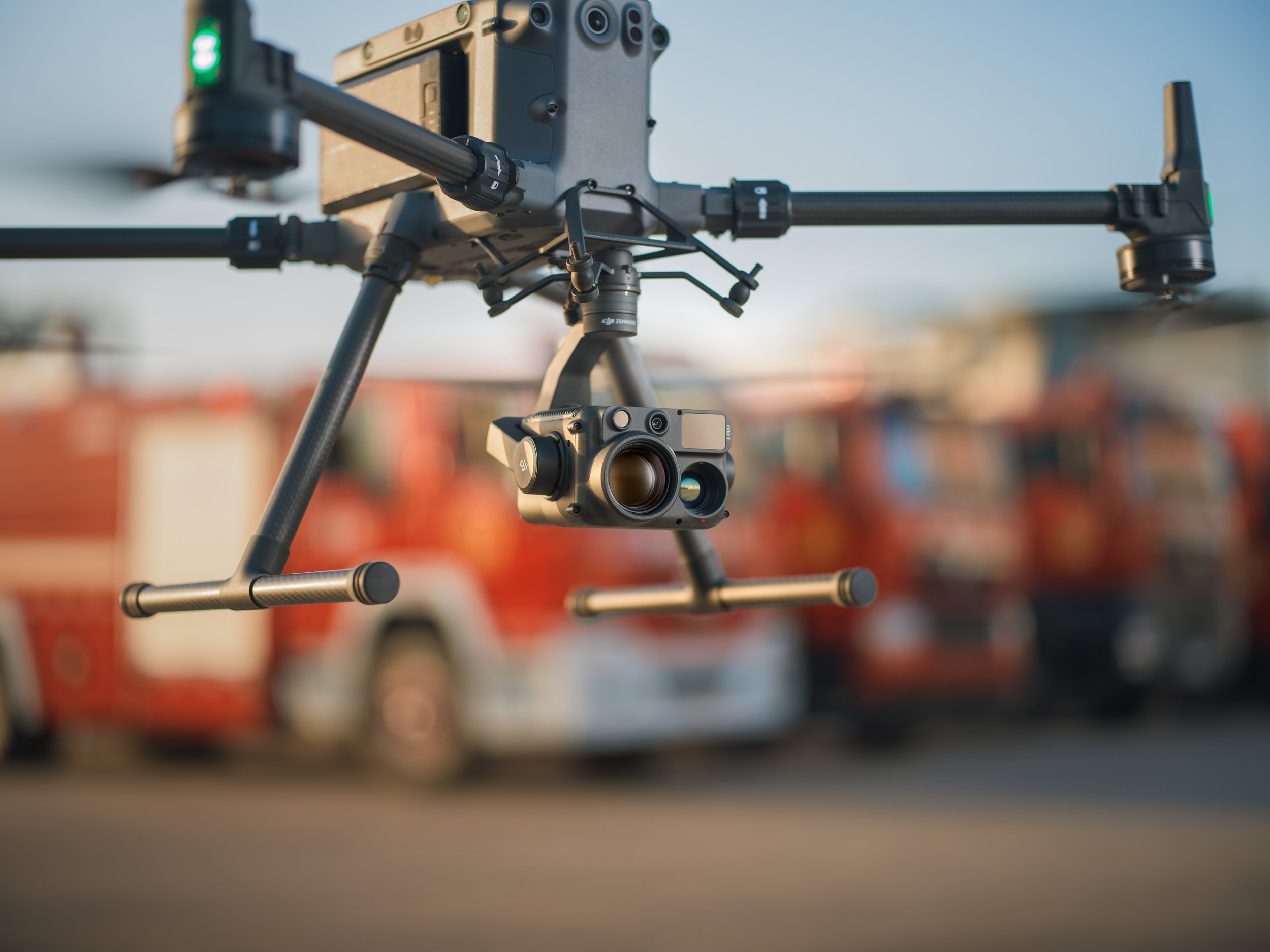
DJI Zenmuse H30T
Multi-Sensor Intelligence for Critical Operations
The DJI Zenmuse H30T combines advanced zoom, thermal imaging and laser rangefinder capabilities into a single integrated payload. Designed for complex inspection, public safety and security operations, it delivers detailed visual intelligence and accurate situational awareness in demanding environments.
Engineered for utilities, emergency response, infrastructure inspection and night operations, the H30T provides the performance, reliability and precision required for mission-critical deployment.
Product Overview
The Zenmuse H30T integrates a high-resolution zoom camera, radiometric thermal sensor and laser rangefinder into a unified multi-sensor system. With enhanced low-light capability, long-distance target identification and real-time temperature measurement, it enables safer and more informed decision-making from the air.
Explore the core capabilities below to understand how the H30T enhances operational visibility, improves response times and supports critical field operations.
Integrated Thermal and Zoom Intelligence
The Zenmuse H30T is built to see further, detect faster and operate in challenging visibility conditions. Combining powerful optical zoom, high-resolution thermal imaging and a laser rangefinder, it enables accurate target identification and measurement at safe stand-off distances.
From power line inspections and asset monitoring to search and rescue and perimeter security, the H30T provides real-time actionable intelligence when it matters most.
Drone Systems
Advanced aerial systems engineered to expand operational capability, accuracy and mission performance.
DJI Matrice 400
The DJI Matrice 400 is an advanced enterprise drone platform engineered for complex industrial operations. With extended endurance, heavy payload capacity and intelligent sensing systems, it supports inspection, infrastructure, utilities and mission-critical deployments at scale.
DJI Dock 3
The DJI Dock 3 is an autonomous drone system designed for continuous remote inspection and public safety operations. Integrating automated deployment with Matrice 4D or 4TD aircraft, it delivers reliable aerial oversight in demanding environments.
DJI Matrice 4E
The DJI Matrice 4E is a compact mapping drone built for high-accuracy surveying and geospatial workflows. Featuring a mechanical shutter wide-angle camera and advanced capture modes, it enables efficient orthophoto and 3D data collection across construction, mining and infrastructure projects.
DJI Matrice 4T
The DJI Matrice 4T is a compact multi-sensor drone designed for inspection, public safety and emergency response operations. Combining high-resolution zoom, thermal imaging and a laser rangefinder, it delivers actionable visual and temperature data for complex missions in challenging environments.
Payloads
Advanced sensor solutions designed to expand capability, accuracy and mission performance.
DJI Zenmuse L3
The Zenmuse L3 is a high precision LiDAR payload designed for detailed 3D mapping and terrain modelling. It captures dense point cloud data with integrated RGB support, making it ideal for surveying, corridor mapping and infrastructure inspection in complex environments.
DJI Zenmuse P1
The Zenmuse P1 is a full frame photogrammetry payload built for efficient large scale mapping. With high resolution imaging and a mechanical shutter, it delivers accurate 2D and 3D data for construction, land surveying and infrastructure projects.
DJI Zenmuse H30T
The Zenmuse H30T combines high resolution zoom optics with thermal imaging for inspection and public safety operations. It enables operators to detect anomalies, monitor assets and gather visual and thermal data from a safe distance.
DJI Zenmuse L2
The Zenmuse L2 integrates LiDAR scanning with an RGB mapping camera to deliver high accuracy terrain capture and asset modelling. It produces reliable point cloud and colourised data for surveying, infrastructure inspection and corridor mapping operations.
Software
Advanced software platforms designed to transform drone data into accurate insight and operational intelligence.
DJI Terra
DJI Terra is a professional drone mapping platform designed for processing aerial imagery and LiDAR datasets. Supporting photogrammetry reconstruction and terrain modelling, it converts captured drone data into accurate maps, 3D models and measurable outputs for surveying, construction and infrastructure analysis.
DJI FlightHub 2
DJI FlightHub 2 is a cloud based drone operations platform designed for remote fleet management and mission coordination. Integrating real time data streaming, flight planning and team collaboration, it provides centralised control and operational visibility for enterprise drone deployments.
FAQs
-
Matrice 400, Matrice 350 RTK, and Matrice 300 RTK (Matrice 300 RTK requires DJI RC Plus). Before use, ensure the aircraft and remote controller firmware are updated to the latest version.
-
The H30T integrates a high-resolution zoom camera, a radiometric thermal imaging sensor and a laser rangefinder into a single multi-sensor payload.
-
The H30T features a 640 × 512 radiometric thermal sensor and supports enhanced resolution modes for improved temperature detail and analysis.
-
The integrated laser rangefinder allows operators to measure distances and pinpoint target locations accurately during inspection and emergency response missions.
-
Yes. The radiometric thermal sensor enables real-time temperature measurement and on-screen temperature analysis during flight.
-
Yes. The H30T is designed for low-light and night operations, supporting inspection, security and public safety deployments in challenging visibility conditions.
-
The H30T is designed for utilities inspection, power line monitoring, industrial asset inspection, search and rescue, fire response and public safety operations.
-
The H30T integrates with DJI Pilot 2, DJI FlightHub 2 and supported SDK platforms for advanced mission planning, remote management and workflow integration.
Speak to our team to discuss pricing, availability and the most suitable configuration for your operational requirements. We can advise on payload selection, regulatory considerations, training and ongoing support to ensure you deploy with confidence.